AI-Based Satellite Image Change Detection using Siamese CNN

AI Satellite Image Change detection
Satellite image change detection

Detect Change. Monitor Growth. Act with Precision.

An AI-driven satellite image analysis system that identifies structural and environmental changes with pixel-level accuracy across large geographic regions.

Pixel-Level

Change Segmentation

Binary change masks output

2+ GB

Annotated Training Dataset

LEVIR-CD supervised learning

Large-Scale

Geographic Coverage

Urban, forest, infrastructure monitoring

Change detection heatmap

SAB's Change Detection System

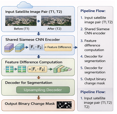
We built a deep learning-powered satellite change detection system using a Siamese CNN architecture. The solution automatically learns feature differences between bi-temporal satellite images to generate precise pixel-level change maps, enabling reliable and scalable landscape monitoring.

Challenge:

  • Difficulty in detecting small structural or building-level changes.
  • High visual similarity between unchanged regions in T1 and T2 images.
  • Illumination, seasonal, and environmental variations in satellite imagery.
  • Large high-resolution images leading to high computational cost and long training time.
  • Requirement of precise pixel-level segmentation instead of simple image classification.
  • Need for scalable monitoring across large geographic areas.
Satellite challenge sample
AI solution for change detection

Solution:

  • Adopted a deep learning-based Siamese CNN architecture for feature comparison.
  • Utilized LEVIR-CD large-scale annotated satellite dataset for supervised training.
  • Learned deep feature representations from before (T1) and after (T2) images.
  • Applied Binary Cross-Entropy and Dice loss for accurate change segmentation.
  • Generated binary pixel-level change masks for reliable landscape monitoring.
  • Enabled a scalable AI pipeline suitable for urban development, deforestation and disaster assessment.

Let's Monitor a Changing World with Intelligent AI

Schedule a Demo